The seven sister states of North East India have always fascinated me. How could such diverse cultures come together under one theme of national integration, barely Geographically connected to India via the 22km Siliguri Corridor or Chicken's neck as it is called. Assam (or Brahmaputra plain) is the connecting strip between all the 6 other states.
When the Bhutan Cycling expedition was planned, I and Tandava booked our travel via Guwahati (Also known as Gateway to the East) but were planning to do some CSR activities supporting Colleges in North East via the Pseudo Government Agency ICT Academy. Travelling to the North Eastern Engineering Colleges and providing support to them would have been so much satisfying, but somehow it didn't work out. So we planned a short trip based on the 3 1/2 day available before we fly out of Guwahati to the Land of Thunder Dragon - Bhutan.
Abhirup had some local contacts from his IIT days and helped me plan the journey in pretty much short time. This was going to be a backpacking sort of journey. Being winter, we expected it to be an off-season period. Rupak (from Assam) suggested we visit Kaziranga as the National park was recently opened.
Monday mornings are always tough, especially if you have to leave for Airport at 3AM. I was skeptical about finding an UBER/OLA ride in the morning, but luckily I got one one and I merrily chatted with him till I got to Airport around 4AM. Few minutes later, Tandava arrived and soon we finished the formalities to board the Spicejet Flight at 6AM. I pretty much slept through the whole journey.


Our Charioteer for the Trip was Apurba Kolita a soft spoken well mannered person from East Assam but now settled in Guwahati. He was on time at the airport and helped us with an early morning Tea at a popular eatery in Guwahati. It is interesting that the name Guwahati means "betel nut market", probably to indicate that affluent market 1600 years back during the Kamarupa regime. Well all the symptom of the flourishing regime was evident the moment we entered the city limits. The population density increased and so did the traffic. I have been fascinated by Brahmaputra river. The 9th largest river in the world, 15th longest, one of the widest (20km in some places), originates at Manasarovar (a place of importance for Indians and Tibetans), the lifeline of the Assam, the mere Geographic characteristics of plains in between Mountains to name a few. Apurba tole me that the water levels have been low this time of the year, however we can have a good view of the river near Tezpur/Kalibor.
Our first destination was Kaziranga. I took some references from net and called up Hotel Bonraja at Bagori right next to the Western Entrance of Kaziranga . Once we left Guwahati, the traffic became sparse, with long stretch of 2 lane roads in between fields with the villages appearing in between. After couple of hours ride we reached Nogaon where we had a traditional Assamese Thali. I personally like the Spinach and the Pumpkin dishes.


An hour later, we were at the Kolia Bhomora bridge across Bramhaputra. A 3km bridge which is also a Historical site for the Ahom Dynasty. There is a rock inscription on the Bhomoraguri hill near the Kolia Bhomora Bridge which states the construction of a rampart by Ahom King Pratap Sinha (1603-41 A.D.) after defeating the Mughals in the Saka year 1538. This is the first Assamese inscription (i.e. the language of the inscription is Assamese). I took a few minutes just to assimilate the vastness of the Brobdingnagian (huge) river. There were at least 12 high power Power Transmission lines in the river bet to connect either sides of the river.
The Roads became single lane from there on, but still sparsely populated. Kaziranga was just an hours drive from the bridge. It is around 400 square Km and 40 km in length on the left of the highway that connects Tezpur to Shivasagar. Kaziranga is home to the endangered species - One Horned Asian Rhino and a Tiger reserve. Apart from them there are elephants, swamp deer, bison and other species to name a few.


As we drove in we had the first spotting of Rhino razing through the swamp. We also spotted Elephants, Wild Boar, Deer, Bison on the drive to Bonraja. It was 4:30pm, when we reached Bonraja, but it was getting dark already. Hareshwar greeted us at Bonraja and showed us the room. Since this was off-season, the rooms were pretty much vacant. He helped us with a Wifi Hotspot and we caught up with all the emails and attended the evening meetings. After dinner, we walked around to the Bagori pick up point. We confirmed that the elephant safari was on and that it was planned for 5am. In the excitement of getting an up close view of the Rhino, I fell asleep.
We got up around 4:30pm and quickly got ready for the safari. The crowd had built up by then. Elephant Safari at Kaziranga is the most sought after one. One could also do Jeep Safari but the most popular is Elephant safari. A 1 hour tour of the sanctuary on top of an elephant. In the past I had seen a video of a tiger attack at Kaziranga and I hoped and prayed that we don't have a similar experience. I was ok even if we don't spot a tiger!
The Elephant Safari comprises of a carriage mounted on top of the elephant which can seat 4 persons excluding the mahout. The ride is for 1 hour. It is difficult to balance on the top, but it is fun once you get used to it. By the time we got the tickets and the Mahouts
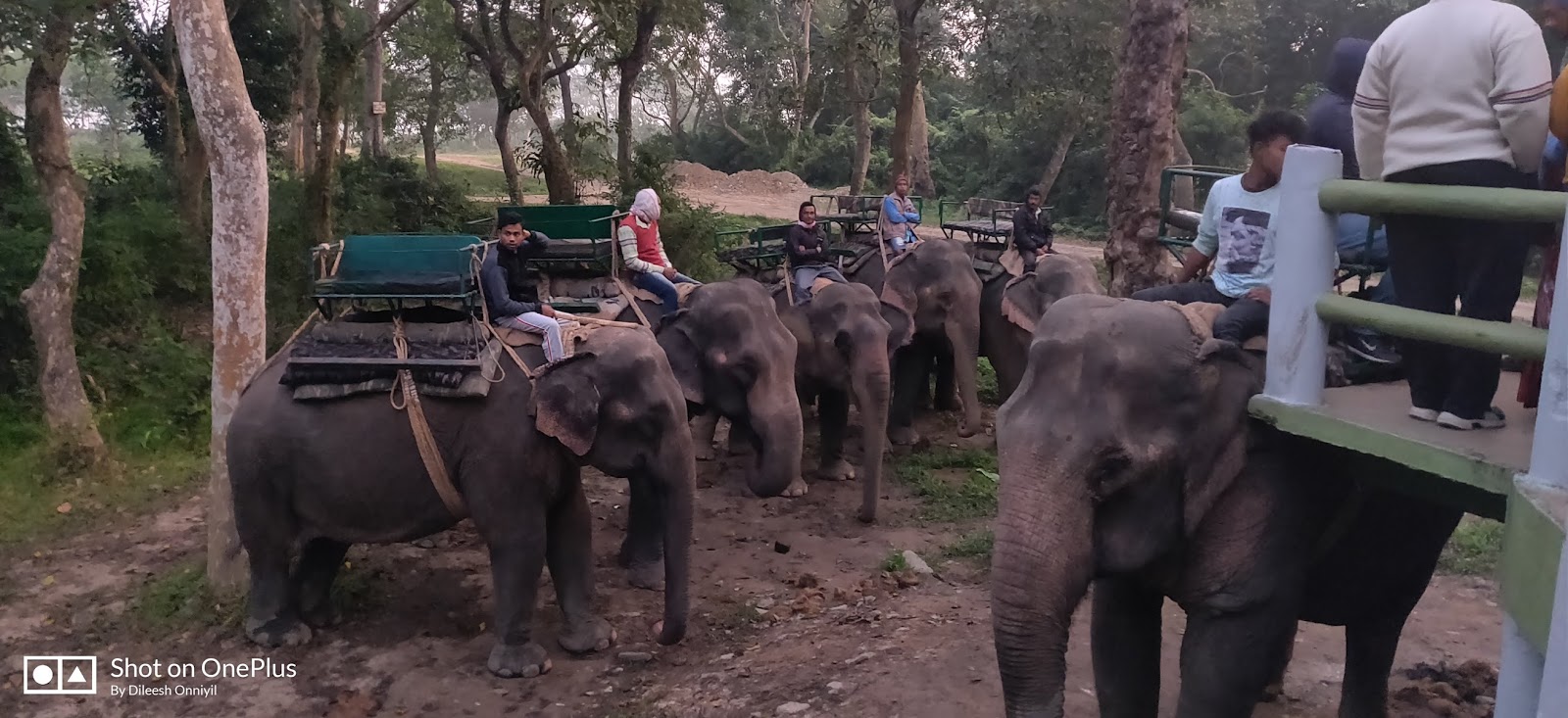
We were joined by an old Bengali couple who were travelling from Delhi. They were very knowledgeable about the Flora and Fauna across India. As the day broke, the ride started and we had good sightings from close range.


My advice : Please don't use the online booking options. They are whopping costly. Try local contacts through the hotels nearby. They work out to be much cheaper. It is even better if you arrive and then inquire at the Kaziranga entry points - West, Central or East. Morning Safari's are better than evening. They are more picturesque.
We had breakfast at Bonraja and were quickly on our way to Meghalaya. I always believed that Tea was grow at higher altitude, but I was surprised to see tea gardens right next to the Kaziranga reserve. A few hours later we reached Jorabat and crossed over to Meghalaya (the land of clouds). It is interesting to note that at one side of the Road, you have all the Petrol stations at Jorbat. The reason being that the road is the boundary between Assam and Meghalya and Petrol is relatively cheaper in Meghalaya due to state concessions. The Road started to wind uphill into the mountains and by 12 we were at Umsning where we had Lunch. We ordered Thali, but wanted to also tempted to try Bamboo Biriyani. Pineapple is grown plenty in the hills so I tried the Pineapple Juice. After lunch we headed uphill to Umiam (Bara pani) lake. The weather started to get cold and I had to layer up soon with the sunset near.

Shillong is horribly crowded and traffic blocks are common. However no one breaks the traffic rules, and hence it is an orderly movement of traffic which takes time but not a deadlock. We headed to Cherrapunjee (Sohra) as we were unconvinced of the stay options in Shillong. En-route, we decided to go to Elephant falls. A 3 stage waterfall named after an Elephant like stone at its foot. In fact its original name was 3 step waterfall in Khasi language. The stone got destroyed in an earthquake in 1897.

As sun set, the hills became backlit with orange lights, like the earlier stages of the Northern lights. The mist started to settle, making it true to its name - Meghalaya, the land of Clouds. We did not book any stay in Sohra. After a couple of scouting options, we found Hotel Labana next to Arwah cave entrance. Apurba also got a drivers room and we decided to call it a day. We did not plan to be in Cherrapunjee but now that we were here, we wanted to make the best use of it. Can we cover Dawki tomorrow which is on another route along with root bridge and few other stops on the way? We weren't sure. Tandava spoke to the boy in the hotel to find out about about the best spots in the area. The water sources had dried up so visiting waterfalls was not best use of our time. The caves were the other option and then Kho Ramaha from where we could see Bangladesh plains. In the thought of the mesmerizing views and the cold night, I fell asleep.
It was 6:00 AM when I woke up, the Sun had started to peep out of the mountain range. I looked out of the Balcony of my room and amazed at the view of the mountains. We spent an hour in the balcony staring at the pristine beauty of the nature chiseled mountains. We were in the land where the highest waterfall happens in the world!

If you are short of time, you do the best things possible. We had options to see the Cave or Nohkalikai Falls. We decided for the falls as it is the tallest plunge waterfall in India. A narrow 5km road led to the waterfall. A rare sight was the Ramakrishna Mission School in Sohra. Kids from poor background were heading to school and the young men heading out to work in the fields.

Nohkalikai Falls is the tallest plunge waterfall in India and the second largest in Asia. Below the falls there has formed a plunge pool in pure Blue color. The falls is named after the tragic story of Noh and Lika. During rainy season, there are multiple streams that take a plunge through the plateau leading to low visibility. Today we had clear visibility but just one stream plunging. We took few pictures and were soon on our way to the Living Root Bridge.
Living root bridges are a form of tree shaping common in Meghalaya. The usually are used by villages to cross a narrow. They are hand by the Khasi and Jaintia peoples who are natives tribes of Meghalaya. Most of them are maintained by villages and have an entry fee. Some are Single deck and some are even Double deck. We headed towards one en-route Mawlynnong. A few kilometers away from Mawlynnong, we stopped at Riwai to see the beautiful man made Phenomenon. A blend of engineering and Nature!


Butterfly on my hand with Living Root bridge behind.
A slight mishap on the way down the hill and I ended up twisting my leg, with Bhutan ride coming up in 2 days time, it wasn't something that I needed! Today is the day for sightseeing, so though I was in pain, I walked through the whole steps down and back.
Mawlynnong was few kilometers away. It was awarded the cleanest village in Asia in 2003. We took a stroll around the village. To be honest, I found the place not so exciting. Yet another clean village, but I felt sad for villagers who lost their privacy in the midst of this liberalization after the award. Few bamboo structures have come up with the board "Bangladesh View"!

From Mawlynnong , a few kilometers through the unpaved roads, we climbed down the hills to Bangladesh boarder. It looked really porous. BSF had few posts and the fencing was starting to appear. The vast expanses of the Bangladesh plains seemed distinctly different from the hilly terrain behind me.


As we rode through the border to Dawki, we stopped by couple of waterfalls - Borhill and Songrampunji. Finally we joined the highway that connects Shillong to Dawki (Indo - Bangladesh border) . We headed to the Bangladesh border point . Through the convoy hundreds of trucks carrying stones to Bangladesh, we finally managed to get to Tamabila, the border crossing!


At Tamabila Zero Point & Bangladesh Flag behind me
It was 3:45pm and the Sun was about to set, we headed straight to the boating point. A 700 Rupee per boat ticket (with 5 person capacity) is all that it costs to see the beauty of the Umngot river. It is claimed to the one of the cleanest and most transparent rivers in India (and in the world). With depths ranging from few feet to around 60 feet. There were few fisher men and women who were around and I noticed this wonderful young Boatman singing a Khasi song which echoed through the hills "Why did you Break my heart!!!"


Me, Tandava and Apurb

Sunset @ Dwaki river with Bangladesh on the left and India on the right

At the border
The lights had faded fast and we had to get back to Shillong for our last night stay in the mountains. I booked Homestead for the night and headed straight to the hotel. We planned to try some local cuisine and in the curiosity, we asked Maria (the host) for a good hotel in Shillong. She advised for City Hut Family Dhaba near Police Bazar. As soon as we entered we realized that it served predominantly North Indian dishes. We had a long day, so decided to eat. at the place. Tandava was still searching for the elusive Bamboo Biriyani. An hour later and after so many oneway routes, we were finally at our resting place. A few issues with Wifi setup, but other than that everything was up to expectations. It has been a long day and I was really tired!
The 5am Biological alarm was working. I woke up, but kept rolling in the bed, so that I don't disturb my partners sleep. By 6, I got up and started to pack. We had a 3:40pm flight to catch to Paro and I had to get the bags in order. I took an hour soaking the sun and viewing the well maintained Homestay.


After breakfast, we quickly thanked the host and were on our way to Guwahati. We already had an experience with Shillong traffic and did not want to impact our flight schedules. After couple of hours drive down the hill, we reached Guwahati. The urge to eat an Assamese Thali was still in our mind. We wanted to try JB's (which was recommended by Abhirup), but due to paucity of time and traffic situation, we decided to have lunch at a Dhaba on the way.

We had few minutes before the scheduled flight (which was delayed by an hour eventually), so Apurba decided to show us his favorite picnic spot - Dipor Bil (Bil stands for Lake - so the lake called Dipor). He and his friends take a break from their hectic driving schedule and come here and cook food and have some good fun once in a year.

Arjun called up: Hey buddy are you coming to Bhutan Expedition or not? Well yes my friend we are at the entrance. JD managed to miss his flight so it was going to be just the 4 of us on this leg with others joining via other flights.

The flight was delayed by an hour and we were just 6 from Guwahati to board the flight. The formalities were completed pretty quickly and we were all excited for the cycling leg.

Up up and Away..... Into the Himalayan Kingdom!
Next up: Cycling through the land of Druk!
4 comments:
Experience the future of eye surgery with Smile Pro Flapless Eye Surgery. Our innovative technique ensures precision and comfort without the need for traditional flap creation. Say goodbye to worries about flap complications and hello to a seamless procedure. With Smile Pro Flapless Eye Surgery, enjoy rapid recovery and enhanced vision clarity. Trust in our expertise to deliver outstanding results tailored to your unique needs. Step into a new era of ocular care where safety and efficacy redefine standards. Choose Smile Pro for flapless surgery that prioritizes your well-being and visual excellence.
https://www.linkedin.com/pulse/smile-pro-eye-surgery-delhi-romila-chaudhary-y5imc/
Experience a new vision of clarity with Silk Laser Eye Surgery. Our state-of-the-art procedure combines precision and comfort for unparalleled results. Bid farewell to glasses and contact lenses as Silk Laser Eye Surgery unveils a world of crisp, clear vision. Trust our skilled professionals to enhance your eyesight with cutting-edge technology and a touch of elegance. Elevate your perspective and embrace the freedom of flawless vision with the sophistication of Silk Laser Eye Surgery. Join the countless individuals who have entrusted us with their sight, enjoying life with renewed focus and clarity. Unleash the beauty of sight through the artistry of Silk Laser Eye Surgery.
https://medium.com/@pojagupta/silk-eye-surgery-elita-860c70c593ad
Great insights! Your post really made me think differently about this topic. I appreciate how clearly you explained everything. Looking forward to more content like this. Keep up the excellent work
How to Reach Spiti Valley from Delhi
How to Reach Jibhi from Delhi
How to Reach Dalhousie from Delhi
How to Reach Jim Corbett from Delhi
How to Reach Auli from Delhi
How to Reach Coorg from Delhi
Nice work on presenting the topic clearly; the flow felt smooth and the explanations were concise, making the post enjoyable to read for many readers.
Kerala Tour Packages Under 10000
best time to visit kerala with family
Wayanad Tour Packages
Shimla Manali Tour Package from Delhi
One Day Trip Places in Kerala
Chennai to Tirupati one day package
Tirupati 1 Day Package from Chennai
Post a Comment